

Key Points
- The southwest monsoon is active along India’s west coast, bringing heavy rainfall to Kerala, Karnataka, Goa, and Maharashtra, with alerts for Konkan, Mumbai, and Thane.
- North India is experiencing thunderstorms, leading to some cooling, though isolated areas may still see high temperatures (40-44°C) today.
- Further cooling is expected from tomorrow as cloud cover increases, with the monsoon likely to progress further into the country.
Weather Overview
On June 15, 2025, India is seeing varied weather conditions. The monsoon is particularly active along the west coast, with heavy rainfall reported in states like Kerala, Karnataka, Goa, and Maharashtra. The India Meteorological Department (IMD) has issued alerts for heavy rain in regions such as Konkan, Mumbai, and Thane, indicating potential for significant precipitation.
Monsoon Progress
The monsoon, which typically spans June to September, has shown signs of revival and progression. It seems likely that the monsoon will continue to advance, bringing increased rainfall activity to various parts of the country in the coming days, based on recent observations.
North India Conditions
In North India, thunderstorms are providing some relief from heat, with temperatures expected to reduce further from tomorrow due to increasing cloud cover. However, some areas may still experience high temperatures today, ranging from 40-44°C.
Survey Note: Detailed Weather and Monsoon Update for India on June 15, 2025
This report provides a comprehensive overview of the current weather and monsoon conditions across India as of 09:36 PM IST on Sunday, June 15, 2025. It integrates information from various sources, including X posts from weather experts and news articles, to offer a detailed picture for stakeholders, researchers, and the general public.
Background and Context
The southwest monsoon is a critical weather phenomenon for India, typically spanning from June to September, driven by southwest winds from the Arabian Sea and Bay of Bengal. It is vital for agriculture, water resources, and the economy, but can also lead to flooding in intense spells. Recent forecasts from the India Meteorological Department (IMD) suggested above-normal rainfall for 2025, with no El Nino conditions, which historically correlate with weaker monsoons. An early onset was noted in some regions, such as Mumbai, in May 2025, linked to warming trends in the Arabian Sea.
Current Weather Conditions
As of June 15, 2025, the weather across India shows significant regional variation:
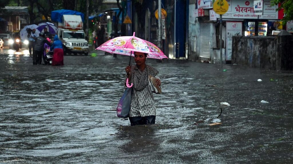
- West Coast and Southern Regions: The monsoon is highly active along the west coast, with heavy rainfall reported in Kerala, Karnataka, Goa, and Maharashtra. Specifically, X posts indicate monsoon cloud bands extending from Kerala to North Karnataka and the Goa coast, with moderate cloud cover off the coast of North Konkan, including Mumbai and Palghar. The IMD has issued heavy rainfall alerts for Konkan, Mumbai, and Thane, suggesting potential for intense rain spells. Coastal areas like coastal Karnataka, Goa, and south Maharashtra have seen significant convection, with heavy showers noted in the past 24 hours.
- North India: The northern plains, including Haryana, Rajasthan, and parts of Uttar Pradesh, are experiencing thunderstorms, which are reducing temperatures. An X post from today mentions that some reduction in temperature is expected today, with thunderstorms forming over North India. However, isolated places may still experience temperatures in the range of 40-44°C. From tomorrow, further cooling is anticipated as cloud cover increases, with moist Easterly winds contributing to the feels-like index but also bringing scattered light to moderate rains with isolated heavy spells.
- Other Regions: Earlier in June, there were reports of heatwaves in parts of North India, with average maximum temperatures crossing 47°C, but recent monsoon activity has started to mitigate these conditions. Northeast India faced monsoon-related challenges earlier, with landslides and floods, but current updates focus more on the west coast’s activity.
Monsoon Performance and Progression
The monsoon’s performance so far has been below normal in many parts, with rainfall deficits noted earlier in June (e.g., -25% below normal as of June 8, 2025). However, conditions have improved recently, with a revival expected from June 12 onwards. X posts suggest that a developing tropical cyclone over the South China Sea is helping intensify the monsoon circulation, leading to rapid progression over east and central India. The west coast, particularly Konkan and parts of Maharashtra, is seeing very enhanced rainfall activity, aligning with the monsoon’s typical pattern of advancing northward and eastward.
The IMD’s model guidance, as cited in X posts, indicates favorable conditions for further monsoon advancement, with increased rainfall expected over the next few days. This aligns with the expectation of above-normal rainfall for the season, potentially benefiting agriculture but also posing risks of flooding in vulnerable areas.
Regional Breakdown
To provide a clearer picture, here is a table summarizing the current weather and monsoon conditions by region:
| Region | Weather Conditions | Monsoon Activity |
|---|---|---|
| West Coast (Kerala, Karnataka, Goa, Maharashtra) | Heavy rainfall, thunderstorms, moderate cloud cover | Active, heavy rainfall alerts for Konkan, Mumbai, Thane |
| North India (Haryana, Rajasthan, UP, etc.) | Thunderstorms, some cooling, isolated high temperatures (40-44°C) | Progressing, expected further cooling from tomorrow |
| Northeast India | Earlier monsoon mayhem (landslides, floods), current focus on west coast | Previously active, current updates limited |
| Central and East India | Likely to see rapid monsoon progression in coming days | Expected intensification due to tropical cyclone influence |
Supporting Observations
Recent X posts highlight specific events, such as significant thunderstorm activity over North Karnataka, South Maharashtra, and Goa, and widespread rains over Sikkim and North Bengal. The presence of moist Easterly winds and strong surface winds in the northern plains is reducing temperatures but increasing humidity, affecting the feels-like temperature. These observations are consistent with the monsoon’s typical behavior of bringing both relief from heat and challenges like flooding.
Implications and Outlook
The current monsoon activity is crucial for replenishing water bodies and supporting kharif crops, given the forecast of above-normal rainfall. However, the heavy rainfall alerts suggest potential for localized flooding, especially in urban areas like Mumbai, where infrastructure challenges were noted earlier in May 2025. The expected cooling in North India from tomorrow could provide relief from heatwaves, but stakeholders should remain watchful for weather updates, particularly in areas with heavy rain alerts.
The monsoon’s progression into central and east India, as suggested by recent developments, could lead to more widespread rainfall, potentially addressing earlier deficits. However, the complexity of monsoon dynamics, influenced by factors like tropical cyclones and regional atmospheric conditions, means that continuous monitoring is essential.
Key Citations
- Monsoon Information India Meteorological Department
- Imd Monsoon Progress
- Monsoon Update Early Onset Indian Express
- India Above Normal Rainfall Monsoon The Hindu
- El Nino Ruled Out Monsoon IMD The Hindu
- Latest Monsoon News India Today
- Indian Monsoon Meteorology Britannica
- Monsoon Updates India Spend
- India Above Normal Monsoon Rainfall 2024 The Hindu
- X Post Monsoon Update Hosalikar KS
- X Post Weather Update Pkusrain